
Walk a Kingsport Street by Address
A street-by-street search in Kingsport is a parcel exercise first. The address gives the starting point, but the parcel number, subdivision, and legal description are what connect records when a street label changes or a corner parcel has more than one way to be described. Start with the public assessment search, then compare the parcel on the county map. The result is a chain of separate records, not a roster of everyone at an address. An assessed owner is a useful lead, and a deed can verify a transfer, but neither alone proves who currently occupies a home.
- Check the complete address with USPS, then enter the address or street in Tennessee Property Assessment Data. A street number is optional in its advanced property-address field, which can help surface candidates on one street.
- Note the property address, owner, control map, group, parcel, subdivision, lot, class, and sale date that TPAD displays. Save enough detail to distinguish similar street names and units.
- Open the Sullivan County GIS viewer, zoom to the segment, and compare a selected parcel with the assessment identifiers. Live map interaction is needed to see what a particular pop-up exposes.
- Use the owner as a grantee in the deed index, locate the transfer, and follow the seller backward as a prior grantee. Read the legal description and prior-instrument reference before moving to the next deed.
- For a historic household, ask the Palmer Room for reverse or criss-cross directories. Use GoVoteTN only for a known voter and address, not as a way to create a street-wide list.
That order keeps the street directory grounded in records that are keyed to land and addresses. It also leaves room for a phone call or counter visit when a web result is incomplete.
Search the Kingsport Street Directory in TPAD
TPAD is the strongest current address-keyed source identified for Kingsport and Sullivan County. Its simple search accepts a property address, owner name, or parcel ID. The advanced form adds owner, property address, subdivision name, classification, sale-date start and end, and parcel components. It also lets the searcher sort by owner name, property address, parcel ID, subdivision, classification, or sale date. There is no inspected ZIP field, so a ZIP must first be turned into a street address or other property key.
| TPAD field | Use for a Kingsport street search | Format or option |
|---|---|---|
| Property Address | Find one address or candidates on a street | Optional; street number may be omitted |
| Owner | Test an assessed owner after an address match | Optional text; examples include a full name or initial |
| Subdivision Name | Narrow a street that crosses a platted area | Optional text |
| Classification and sale dates | Refine results without treating them as occupancy proof | Dropdown and optional date range |
| Control map, group, parcel | Match the assessment record to map and deed clues | Three-number control map, optional letters, and parcel format |
TPAD displayed Tax Year 2026 and an update date of July 26, 2026 during research. Treat that as a freshness marker, not a guarantee that every detail is current. Its visible results list owner, property address, control map, group, parcel, special interest, parcel ID, subdivision, lot, class, and sale date. The captured result text did not safely show every detail-card field, so check the actual card or contact the assessor before relying on mailing, exemption, value, sketch, or legal-description details.
Note: The Sullivan County assessor can clarify an assessment record by phone or at the Blountville counter when a TPAD result needs confirmation.
Kingsport Street Records Need the Right Key
Three address terms prevent common mistakes in a Kingsport street search. A situs address is the physical property location used for assessment or service. A mailing address is where a tax notice is sent. A legal description is the lot, block, subdivision, or metes-and-bounds wording that identifies land in a recorded instrument. The three may point to the same place, but they serve different systems. A street address is convenient for TPAD and USPS. A deed often depends on the legal description instead.
- Parcel
- A numbered assessment and map unit used to connect a property record with a particular piece of land.
- Situs address
- The physical location of the property. It is not automatically the owner’s mailing location.
- Plat
- A recorded map that lays out lots, blocks, streets, or subdivisions. Plat books can bridge a street address and deed description.
- Criss-cross directory
- A historical directory arranged by address rather than surname. The Palmer Room’s exact reverse-directory runs need to be confirmed with library staff.
A tax mailing address outside Kingsport can reflect an entity, an estate, a trust, an absentee owner, or a different place where the owner receives notices. It does not identify who lives at the property. Likewise, a special-interest indicator can prompt further checking but is not conclusive proof of occupancy. This is the key local myth to avoid when reading an address record.
Turn a Kingsport Parcel Into a Deed
After TPAD and GIS identify the parcel, the Sullivan County Register of Deeds is the next custodian for recorded transfers, plats, liens, easements, releases, and related instruments. Search the current owner as the grantee to find the purchase instrument. The seller is the grantor. Read the recording date, book or document reference, legal description, and any reference to an earlier instrument. Then search that seller as a grantee to work backward through the chain.
The online coverage dates published in title-search vendor metadata are leads to confirm with the office. They report deed index information from 1930 and images from 1980, while older index books are identified for 1770 through 1930 and several non-indexed series reach into the twentieth century. The Sullivan-specific live portal did not expose its rendered form, image terms, or full options during research. Call the Register at (423) 323-6420 or visit its Blountville office for grantor/grantee books, plat books, images, and certified-copy procedure before treating a cutoff or access rule as final.
For an older Kingsport street directory trail, the counter route matters. A modern address may not appear in an older book. Use the subdivision, lot, control-map clues, or deed legal description when the street label does not search cleanly. This contrast between current TPAD columns and older deed books is an important local access difference, not a reason to assume the land history has ended.
Kingsport Street Permit History
Kingsport eTRAKiT permit search provides another address-led trail through permit, planning, property, inspection, license, and violation modules. An address and date range can help identify a project or inspection chronology, with names shown only where the public result exposes them. The exact live search fields and record cutoff were not captured, so use the portal as a place to test an address rather than assuming all project details or periods will appear.
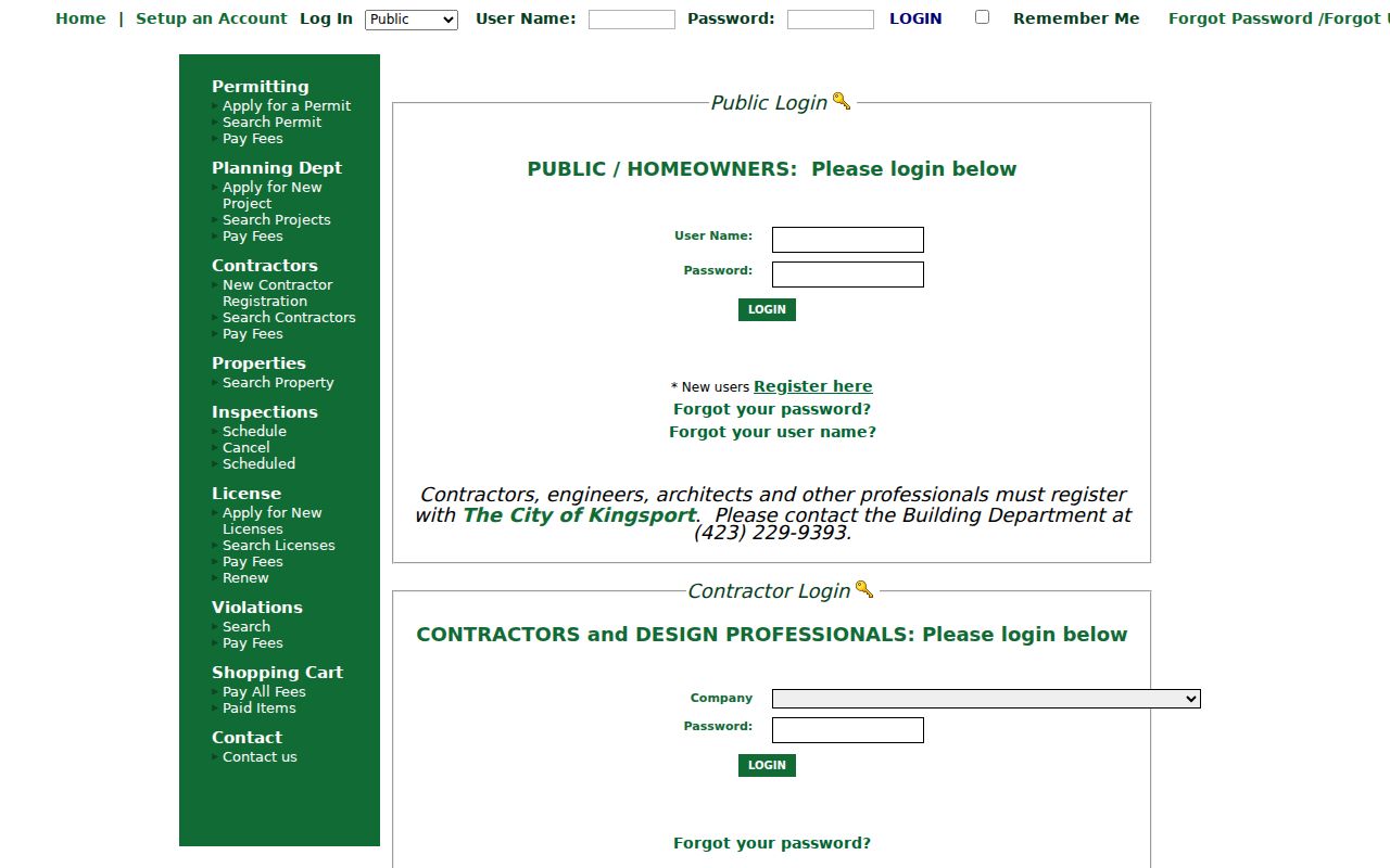
The permit-search screen is useful for keeping the city record separate from the property record. Confirm ownership through TPAD and deeds rather than treating a permit applicant or contractor as the owner. The Kingsport Building Department also offers a counter at 415 Broad Street, first floor, and can be reached at (423) 229-9393 during its listed service hours.
Kingsport Street Maps and Annexation Context
The county GIS is a map clue, not a boundary survey. Kingsport’s planning instructions say to enter an address, open the map-layers control, expand Planning Department Public Layers, and choose City Zoning. The city says that layer includes current data and the Urban Growth Boundary line. The Kingsport Map Gallery also links to city-limit, annexation-by-decade, zoning, tax-map, school, police-zone, and 1906 plan materials. Those sources can explain which jurisdiction and historical map context applies to a street.
They cannot establish a legal property boundary. The city warns that map products were prepared for internal GIS purposes and are not warranted for parcel boundaries or dimensions. GIS geometry can also lag a replat or annexation. When the street directory needs title evidence, use the legal description and recorded deed. When it needs municipal context, compare the map layer and the current planning materials.
Note: Kingsport has changed through annexation and subdivision growth, so retain the historic address form alongside the current parcel identifiers.
Kingsport Street Records and Access
Address-keyed sources overlap, but they do not answer the same question. The table below keeps the Kingsport street directory focused on what each record can actually show and where the documented fallback lies. Start online when the record is searchable, then use the phone, counter, library, or older books when it is not.
| Address record | What it can show | Kingsport or Sullivan access |
|---|---|---|
| TPAD assessment | Assessed owner, property address, parcel components, subdivision, class, sale clues | Public TPAD search, assessor phone, or Blountville counter |
| County GIS | Parcel geometry, map context, and identifiers | Public ArcGIS entry point; inspect the live parcel pop-up |
| Recorded deeds and plats | Grantors, grantees, transfer references, legal descriptions, and plats | US Title Search lead plus Register of Deeds counter and older books |
| eTRAKiT | Permit, inspection, planning, license, or violation clues by address | Public portal or Building Department counter |
| Palmer Room sources | Historical address and telephone-directory entries | Library research and staff assistance; ask for exact reverse runs |
For a person already identified by name, Tennessee’s voter tools can confirm a particular lookup under their own rules. They are not a block or street roster. GoVoteTN supports name plus optional ZIP and an address mode, while the state lookup requires county, first name, last name, birth month, and birth year. The Sullivan County Election Commission is the right place to ask about current voter-record access or a record mismatch.
Kingsport Street Addresses Cross ZIP Lines
A Kingsport postal name does not settle city limits or county jurisdiction. The research identifies Colonial Heights with ZIP 37663 and Lynn Garden with ZIP 37665 as local examples of a postal label that should be kept separate from a municipal line. A property can carry a Kingsport mailing label while sitting in unincorporated county geography. Kingsport also has a small municipal footprint in Hawkins County, so the correct county custodian must be confirmed for a particular parcel.
Use USPS ZIP Lookup with a complete delivery address, then compare the postal result with city-limit and annexation maps. Search variants matter: include the house number, compass direction, suffix, unit, subdivision, parcel identifiers, and old or new street wording where known. The city’s research did not locate an official year-specific renumbering project, so a claimed renumbering date should not be assumed.
Historical Kingsport Street Address Sources
The Kingsport Library Palmer Room is the historical fallback for directories, telephone books, maps, census resources, indexes, and newspaper microfilm. Ask staff for a reverse or criss-cross directory by the exact address and era, because an official full run and a sample page were not located during research. A listing is evidence of a dated directory entry, not proof of a current resident or ownership.
The 1906 Kingsport plan, 1916 and 1925 Sanborn sheets, and annexation maps can help bridge a block across changing names and boundaries. Deeds still answer title questions. For a deeper directory-era household search, the historical collections are treated separately on the Kingsport city directories page, where the library and archive access paths take priority.
Kingsport Street Directory Boundaries
A public address search cannot reveal every person connected with a home. It does not supply a complete household list, private utility customers, driver records, protected-victim locations, or an unrecorded move. Records also carry different dates. An owner record, permit, directory entry, voter result, deed, and obituary may all be accurate for their own event while describing different points in time.
Protected addresses deserve special care. Tennessee’s Safe at Home program provides a substitute address for qualifying participants in government uses, while certain voter identifiers and Department of Safety information are withheld. Do not try to reverse-engineer a protected location from partial records. For a correction, request help from the record custodian that created the entry rather than copying an uncertain result into another search.
Lawful personal research. Use Kingsport street and parcel records for legitimate personal, family-history, property, or civic questions. Never use an address trail to stalk, harass, intimidate, or harm a person.